Far East Farmers | Our Planet, Our Home
Awards & Nominations
Far East Farmers has received the following awards and nominations. Way to go!
The Challenge | Our Planet, Our Home
Far East Farmers
Farm planning using machine learning: predict crop suitability with climate data.

We’ve built something amazing yet simple for the farming industry to discover agricultural opportunities or risks.
By combining USDA agricultural usage data with NASA climate and weather data, we’re able to spatially predict agricultural land suitability across a number of crops such as corn, soybeans, and rice just to name a few.
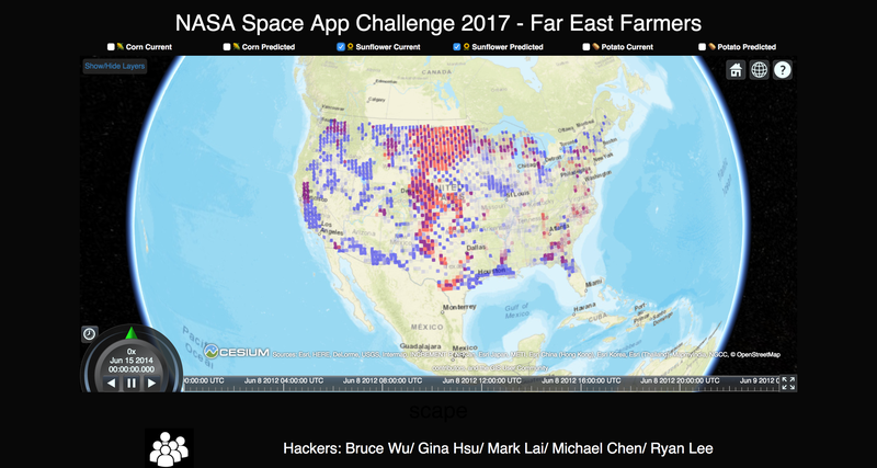
In the demo app we've created predictions using a 50-square-kilometer resolution. Tiles colored red indicate where crops are grown currently, and blue tiles indicate areas with climate similar to those where the specified type of crop is currently prevalent.
As a brief technical explanation, this was generated using a random forest regression that takes in weather features from NASA to predict crop usage at each tile. We expect to incorporate more features and more fine-tuned predictive models in the future.
In essence, for any crop, we’re able to identify where we expect it to grow best based on climate data such as precipitation and temperature.
The areas of overlap between the predicted and current farming usage will appear purple. Areas that are more blue are opportunities for that crop - these tiles experience weather similar to other areas currently used for that crop. Areas that are more red are those that may experience suboptimal growing climate, even though they are currently being used for that crop.
As the climate changes over the years, it will be important for the industry to know what to expect and how to mitigate changes in land areas suitable for growing different types of crops. For example, the nation’s demand for corn seems to have outpaced the amount of available area where the climate would predict good corn growth. On the other hand, although there is ample suitable land for potato farming, we don’t see much of it used for potatoes.
Our vision is to create a platform that serves as a hub for nationwide corporations as well as family farmers to upload their own data so that we can give them even better predictions at varying resolutions. For instance, on a local level at high resolution in California, we can help Napa Valley winemakers predict the best plots of land for each grape varietal. In the spirit of collaboration, we plan to open-source the project so that others can play with the models and use their own data.
We’re so grateful to have placed in the NASA Silicon Valley Space Apps Challenge and we look forward to bringing our passion to the next level. Thanks to everyone for your support.
SpaceApps is a NASA incubator innovation program.