Lemon Py | Trace Invaders
Buenos Aires
Awards & Nominations
Lemon Py has received the following awards and nominations. Way to go!
 Best Use of Data

The Challenge | Trace Invaders
Develop a tool to trace invasive species in yourneighborhood over time!
Pollen alert: the allergen compass
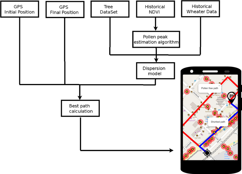
Almost 10% of Buenos Aires city trees are from Platanus genus. These exotic trees produce a large amount of pollen that can cause allergy. Our app shows allergen spatiotemporal distribution and route people to their destination minimizing pollen exposure.

The observation:
Almost 10% of Buenos Aires city trees are from Platanus genus. These exotic trees that are often known in English as planes or plane trees, produce a large amount of pollen and volatile particles that cause allergy [3]
The questions:
- Can we predict Buenos Aires city trees' allergen production and dispersion?
- Can we use this model to route citizens minimizing their pollen exposure?
- Can we expand our idea to other cities? (Including cities without tree data availability?)
- Can we use this data to predict other tree related phenomena such as fruit production and ripening?
The data:
- Buenos Aires city official tree database: https://data.buenosaires.gob.ar/dataset/arbolado-p...
- Landsat 8 Operational Land Imager (OLI) images https://landsatlook.usgs.gov/
- Weather APIs (OpenWeatherMap, Wezzoo, The Weather Company, etc).
The idea:
- Use the tree dataset to find particle producing trees and locate them.
- Fetch historical Landsat 8 band 4 and 5 imagery for these locations.
- Calculate the NDVI (https://en.wikipedia.org/wiki/Normalized_Differenc...) for each location and time point.
- Try to correlate NDVI signal with critical moments of the tree life cycle in order to predict future allergen producing events [4].
- Use these allergen sources and climate data as an input to a dispersion model [2] [3].
Progress made:
- City map with all the trees of the city: http://bit.ly/2oYrZS8
- Calculated NDVI from a random sample of trees [6].
- Team Repository: https://github.com/Lemon-Py/
This project is being developed with:
Future perspectives:
- Improve our tree dataset using different data sources (social media, user input through the app, Google street view) combined with classification algorithms [5], image recognition and user feedback. Our intention is to be able to quickly expand our data, with trees [1] [7] and weather forecasts from many cities in the world. For example, Melbourne (Australia) already has an open tree dataset that we can use.
- Internet has tons of weather APIs that we can combine with our data to predict the distribution of pollen in the cities and even the whole world [2] [3] [4] [8]. APIs like OpenWeatherMap, Wezzoo, and many others use information from:
- Social media machine learning algorithms.
- Mobile devices sensors.
- User feedback.
- Real time radars.
- Get satellital images with higher spacial resolution from more satellites like Sentinel-2, to be able to calculate the NDVI of each tree with a better precision.
Bibliography:
- Törmä, M., Lumme, J., Pyysalo, U., Patrikainen, N., & Luojus, K. (2004). Tree species classification using ers sar and modis ndvi images. International Archives of Photogrammetry Remote Sensing and Spatial Information Sciences, 35(7), 927-932.
- Pietrowicz, J., & Pasken, R. (2002). The Use of mesoscale meteorological models as a tool for pollen Concentration Forecasts.
- Alcázar, P., Cariñanos, P., De Castro, C., Guerra, F., Moreno, C., Domínguez-Vilches, E., & Galán, C. (2004). Airbone plane-tree (Platanus hispanica) pollen distribution in the city of Cordoba, South-western Spain, and possible implications on pollen allergy. Journal of Investigational Allergology and Clinical Immunology, 14, 238-243.
- Skjøth, C. A., Ørby, P. V., Becker, T., Geels, C., Schlünssen, V., Sigsgaard, T., ... & Hertel, O. (2013). Identifying urban sources as cause of elevated grass pollen concentrations using GIS and remote sensing. Biogeosciences, 10(1), 541-554.
- Zhang, K., & Hu, B. (2012). Individual urban tree species classification using very high spatial resolution airborne multi-spectral imagery using longitudinal profiles. Remote Sensing, 4(6), 1741-1757.
- Peng, D., Jiang, Z., Huete, A. R., Ponce-Campos, G. E., Nguyen, U., & Luvall, J. C. (2013). Response of spectral reflectances and vegetation indices on varying juniper cone densities. Remote Sensing, 5(10), 5330-5345.
- Xu, J., Cai, Z., Wang, T., Liu, G., Tang, P., & Ye, X. (2016). Exploring Spatial Distribution of Pollen Allergenic Risk Zones in Urban China. Sustainability, 8(10), 978.
- Weinberger, K. R. (2015). Spatial and Temporal Distribution of Tree Pollen in New York City: Linking Aeroallergen Measurements to Health. Columbia University.
SpaceApps is a NASA incubator innovation program.