Fire Geeks | And YOU can Help Fight Fires!
Awards & Nominations
Fire Geeks has received the following awards and nominations. Way to go!
The Challenge | And YOU can Help Fight Fires!
Alive Forest Sensor
A device attached to the animals body that gonna send an alert and Location throw WSN ( Wirless Sensor Network) when exposed to Smoke or heat .

1-why we solve the Fire problem ?
*Chile's Wildfire : On January 27-28, a wildfire described as the worst in Chile's modern history killed at least 11 people , including five firefighters and destroyed the town of Santa Olga in the central Maule Region displacing thousands of people . (https://en.wikipedia.org/wiki/2017_Chile_wildfires)
* The great smoky mountains Wildfires : The fires have claimed at least 14 lives,injured 134,and are one the largest natural disasters in the history of Tennessee.the fires had burned more than 10,000 acres (15 square miles) inside the national park, and 6,000 acres in other parts of the area. At least 14,000 area residents and tourists were forced to evacuate, while over 2000 buildings were damaged and/or destroyed .
* The 2013 Central Kansas wildfire : was a very dangerous wildfire that cost the lives of 22 people, made 2 others go missing, and caused $144 million in damages. It was a very long lived wildfire as well, having burnt 272,000 acres of land whilst active, before being contained and put out by June 21st .
*The 2013 California wildfires : burned at least 577,675 acres (2,337.77 km 2) of land in the state of California, during 2013. The wildfires injured at least 125 people and killed at least 1, and caused over $218.15 million (2013 USD) in damage .These included several large, notable wildfires, including the Rim Fire, which became California's 3rd largest wildfire. One of the wildfires was also caused by the plane crash of the Asians Airlines Flight 214 on July 6, 2013, which ignited a wildfire that burned around 1 acre of land .
2-what is the purpose of Forest Sensors ?
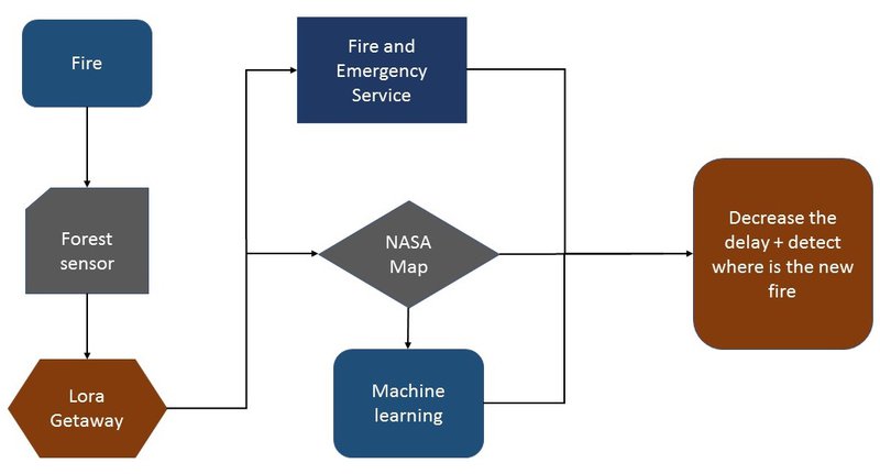
by our sensors that already built on the animals we will be able to measure the temperature and smoke and send all data by LoRa technology
3-what is the function of LoRa Gateways ?
the gateways will get the data from all sensors near to it after that we will be able to see all the data and the analysis on the screen that on the control center.
4-how we can find the Fire ?
during getting the data from all sensors and GPS we will able to see wither there is any fire or not and the location of it.
5-what is the NASA Map ?
it is the data(API) that we will get it from NASA satellite.
6-how the Machine Learning will work and why ?
by comparing the past data(NASA satellites) and real data(from sensors) we will be able to know where is the fire within 5 second instead of the 5 hours that from NASA satellite. on other hand we will compare the real data (from sensors) and the past data(API) (from NASA satellites) to detect the new fire when and where it will happen .
NASA Near Real-Time Data and Imagery (https://earthdata.nasa.gov/earth-observation-data/...)
>Advantage :
1-Using animals as Alive Forest Sensors Enables a more dynamic and wider detection as compared to fixed sensors .
2- The fewer Sensors Needed means a significant reduction in cost compared to fixed sensors.
3-Since animals can go where human can not , previously unreachable areas can now be controlled.
4-Classification of animals individual and group behavior can be used for other purposes , in particular , the system may be use to detect poaching and monitor comprehensive animal deaths .
5-Decries the delay of detecting the fire and Locating it .
>Disadvantages :
1- its hard put the device in Animals we need help in attached it to the animals ( but with our Long-term battery it will be every 5 years to replace it ) .
2-the animal gonna be hunted or die that's a risk we have to accept but (we could choose animals from top of the food chain , also it gonna give us data and information's about this animal life ).
SpaceApps is a NASA incubator innovation program.