GalaxCY | And YOU can Help Fight Fires!
Awards & Nominations
GalaxCY has received the following awards and nominations. Way to go!
The Challenge | And YOU can Help Fight Fires!
Protego
Protego detects fire, alerts the local authorities and notifies the general public. We orchestrate a greener future.

OUR VISION
To orchestrate a greener future! We do this through our Protego system. Let's explore it!
OUR SOLUTION
Our team, provides real-time forest data to the fire department for early fire detection. Our system combines various NASA Satellite data, and data from our own devices, called Protego, to assist fire departments in responding more quickly, accurately and cost-effectively to fire threats in forest areas. We have developed a demo mobile application for firefighters and the general public, a system of forest sensors called Protego and quite a few extra features, such as pre-fire and post-fire additions.
OUR HARDWARE
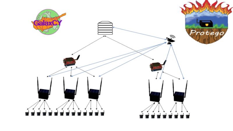
Protego devices are strategically placed sensor nodes in the forest to detect fire in its early stage. With a Star Topology Network, the devices are connected wirelessly and transmit live data to a central hub, from which the data is distributed to a globally accessible server. Having multiple layers of fault-tolerance, the Protego devices will enter hybrid mode to remain online even under the worst circumstances.
The Protego grid is a live representation of the situation on the ground. It is available both to the forest fire department and the general public and contains multiple view modes: MODIS, VIIRS, Protego, User Reports. The modes can be overlayed along with a visual location of marked fire watchtowers.
Link to Full Documentation: https://github.com/bilibull/
OUR SOFTWARE
With our Protego Android app, the general public can also contribute by identifying fire and other kinds of hazards via reports through a truly innovative in-app procedure. In addition, in an emergency scenario a person is able to send an SOS alert and call a medic through a user-friendly experience. Even if someone is hiking or mountain biking carefree in the forest, in the event of a raised alarm, he will immediately be notified through our app and be prompted to follow the suggested evacuation route, which is based on his exact map location, where the fire is now, and where the fire is spreading. This information is calculated by computing NASA Terra Satellite data, and Protego devices data.
From the fire department’s perspective, fire management becomes much simpler. We provide a live aerial camera feed in a matter of minutes and display the exact coordinates of civilian reports, people in vulnerable situations, and deployed firefighters.
Last but not least, we provide the local authorities with pre-fire predictions of fire-prone areas and post-fire predicitons of possible future hazards.
Learn more about our Android Application!
OUR TEAM
Team GalaxCY is made up of four hardworking and passionate men from the picturesque island of Cyprus. We are:
- Andreas Neophitou
- Manos Iliades
- Orestis Skoutellas
- Vasilis Horga
We have been trained in electronics and robotics by Epiteugma Training Center since January 2017!
Link to Full Documentation: https://github.com/bilibull/
RESOURCES
Github Link to full documentation: https://github.com/bilibull/
Android Studio, Arduino, Matlab, Octave, ArcGIS, Panoply, Prezi
LICENCES
Video Music: Pamgaea Kevin MacLeod (incompetech.com)
Licensed under Creative Commons: By Attribution 3.0 License http://creativecommons.org/licenses/by/3.0/
The Protego System, GalaxCY Protego Android APK, and documentation is licensed under the Apache License 2.0
SpaceApps is a NASA incubator innovation program.