Earth Alert | When Landslides Strike
The Challenge | When Landslides Strike
SLIDE: Suspected Landslide IDentification Environment
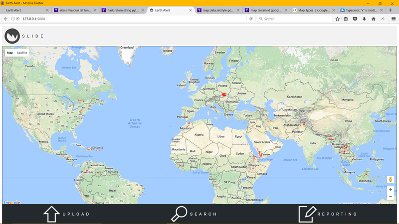
Our web-based application allows users to view worldwide landslide threat levels, receive location based warnings through SMS messages, and improve the NASA landslide forecasting model through event reporting and image uploading.

Our challenge was to design an easy-to-use tool to allow the public to discover and understand landslide data, and to contribute their own observations for use by emergency managers. NASA has created a Global Landslide Nowcast that predicts areas most at risk for landslides based on historical landslide records and 7-day precipitation data. This information is publicly available through the Precipitation Measurement Missions API, but is difficult to access and understand, especially for those with limited or no internet access as may occur in a disaster situation. Our team, Earth Alert, built a website application that allows for simple access and interpretation of the existing NASA model and improves the model through the power of community contributions.
Link to GitHub Repository: https://github.com/mjhouse/earthalert
The main features of our application:
- Global Landslide Nowcast projected on Google Maps
- Retrieves user location and provides alert level based on model
- Allows users to enter reports of landslide events
- Allows users to upload images that appear on map
- Fully responsive on mobile devices
- Takes SMS messages, gets geolocation, and responds to message with threat level
- Model is updated based on community reports
- Incorporate socioeconomic data into the model to help those most at risk
- Provides preparation information for those in high threat level areas
Resources Used
Our website is built on Flask, a Python microframework for website development. The frontend of the website is designed with Javascipt, CSS, and HTML. We utilize the NASA Precipitation Measurement Mission API, in particular the Global Landslide Nowcast updated every 30 minutes. We also use the Google Maps developer API to display the map with the model layered over. Twilio is used to send and receive text messages. Our socieconomic data comes from OECD and is used to update the threat level. Geocodio allows us to retrieve geo data from text messages in order to determine the threat level for the location of a user. Our website is running on a Digital Ocean server. Git and GitHub were used for version control, and Slack was used for communication and sharing of small files.
Challenges Faced
VERSION CONTROL! Even using Git and GitHub for version control, we ran into numerous issues with ensuring that everyone was running the same version and had all the required packages. Those of us not familiar with Git quickly became adept at resolving merge conflicts and the add, commit, push flow. Several Python packages also gave us trouble as they were not compatible on all of our computers, but we eventually found alternatives or wrote our own functions to solve the issues. One humorous issue we faced occurred at shortly after midnight on Sunday morning. We were repeatedly making requests to the NASA PMM API and receiving errors in response. After 15 minutes of frantic panicking, we finally realized that there was not yet a map available for the new day and we had to set our adjust our code to request a slightly older map (and then updated once the new maps became available). Sending and receiving text messages was difficult to figure out, and we are almost through with our free account funds.
At Earth Alert, we don't think you should have to use an API to access life-saving information. By enabling access to existing NASA resources, we are able to provide vital data to those who need it most. Moreover, our model dynamically adapts to community contributions, allowing users to improve the forecast and share information that can help themselves and others.
SpaceApps is a NASA incubator innovation program.