NRD | When Landslides Strike
The Challenge | When Landslides Strike
Land Slides Bolivia
Prevention application that integrates the power of NASA's open satellite data with ground sensor-based data to predict the risk of land slides in the city of La Paz, we took Kallapa's land slides as use case.

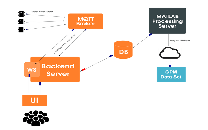
Satellite data for rain prediction is very useful when integrated with ground data we get interesting results. It's possible to get a risk of land slide when processing sensor data with NASA's satellite (pre-processed by us to reduce execution time and increase response). All devices uses a Photon board which is a production ready device with IoT integration and a very important feature which is Smart Config which makes it easy to have a device ready for production and usage wich integrated with the Phonton smart-phone application we can configure the device internet access without the need of re-programming the device. These devices are located in different zones of La Paz city which are always in danger of land slides.
With the usage of MQTT protocol -a light protocol for low internet connections, which is the case of La Paz city-, devices sends data to our AWS-based backend.
On the other hand we have a pre-processing application which processes NASA satellite data which is in HDF5 format. We are using the level 3 algorithm which the most useful for our case.
Once device data gets to the backend server, it processes risk of land slides by integrating and interpreting pre-processed NASA data. Once processed it returns via a web-socket to the browser in order to give a real time look-and-feel.
The technologies used for this project are:
- Backend Application using NodeJS express framework
- Pre-Processing for NASA's satellite data in MatLab
- Sensor-backend connectivity layer using Mosquitto Message broker
- Frontend User Interface using AngularJS framework
- Infrastructure running on AWS
- Continuous Integration and Continuous Delivery using Jenkins and Red Hat Ansible
SpaceApps is a NASA incubator innovation program.